Introduction
India’s infrastructure and industrial growth story in 2025 is changing the face of the nation with metro networks, expressways, renewable energy parks and greenfield industrial clusters. But every big project starts with a small step, which is a land survey. Developers, EPC contractors and government agencies need survey data that is faster, sharper and reliable. To meet these requirements, SES Digital provides drone mapping services in India combined with LiDAR, photogrammetry and high-definition 3D laser scanning services. Our survey engineers, drone pilots, GIS specialists and CAD technicians work closely to produce orthomosaic maps, digital elevation models and detailed 3D point clouds that power precise decisions for infrastructure, real estate, mining and utilities.
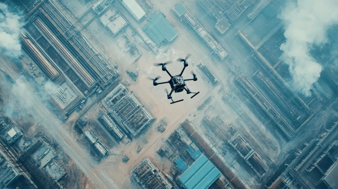
What is Drone Mapping and How It Works
SES Digital’s drone mapping services harness advanced geospatial mapping and surveying technologies to redefine land surveying standards in India:
- Orthomosaic Mapping
We fly drones with RGB and multispectral cameras over the survey area and capture thousands of overlapping images. These are then processed using photogrammetry software to create highly detailed 2D maps, where distortions are corrected for scale and perspective. These maps are great for site planning, boundary demarcation and progress tracking.
- LiDAR Scanning
For projects that require granular detail, we equip drones with LiDAR (Light Detection and Ranging) sensor payloads. It gives an ultra-precise 3D point cloud of every elevation change, slope and obstruction. We integrate LiDAR data to produce Digital Terrain Models (DTMs) and Digital Surface Models (DSMs) that architects and engineers trust for making critical design decisions regarding site selection, risks, environmental impact, etc.
- 3D Models
Our laser scanning services in Gujarat and pan-India help you create an exact digital replica of existing assets with dimensions, alignments and spatial details. These 3D models remove uncertainty and enable accurate planning for brownfield plant expansions, structural integrity checks, etc.
Top Industries Benefiting in 2025
- Real Estate & Urban Planning
Developers use drone mapping services for land grading, topography and project progress monitoring. SES Digital’s orthomosaic deliverables help architects optimize layouts as per regulatory norms.
- Infrastructure Development
Roads, railways and power corridors require corridor mapping over large land areas. Drones reduce survey timelines from months to days. Our 3D laser scanning services in India support infrastructure projects by providing precise alignment data and clash detection insights.
- Mining & Quarrying
Stockpile calculations, pit optimization and slope stability studies were traditionally time-consuming and risky. Our LiDAR and photogrammetry-based drone mapping makes them faster, safer and budget-friendly.
- Utilities & Energy
Transmission lines, gas pipelines and solar farms require frequent inspections and terrain mapping. Drones with thermal sensors and LiDAR allow us to do this without disrupting operations.
Combining Drone Mapping with 3D Laser Scanning Services
The accuracy of land surveys is greatly increased when drones equipped with laser scanning devices are used. Millions of data points are collected by this combination to produce high-density point clouds that precisely map each obstruction, elevation and contour. For large infrastructure corridors, mining leases and urban layouts, SES Digital uses this hybrid workflow to produce survey-grade outputs that reduce ambiguity, speed up design approvals and provide an authoritative geospatial baseline for all stakeholders.
Conclusion
Delays or inaccuracies at the stage of land surveys can blow up timelines and budgets. Our drone mapping, combined with laser scanning services in Gujarat and pan-India, gives you precise spatial data, faster data acquisition and safe access to difficult-to-access terrain. We provide solutions that convert raw topographic data into actionable insights for engineers, architects and project managers. In an era of speed and smart technology, partnering with SES Digital will deliver the foundation you need to build faster and smarter.