Introduction
The sun is supremely powerful. Its energy reserve is nearly inexhaustible. The quest to tap the tremendous potential of solar energy has given impetus to utility and commercial-level solar power plant projects by photovoltaic (PV) technology. And sustaining their energy efficiency with the help of revolutionary drones for solar power plant surveys is a priority of SES Digital.
Topographical and Thermography survey
Hassle-free installation and effective functioning of a solar power plant call for accurate Topographical and Thermograph survey regularly.
Such inspections aid in plant construction and ensure value-delivery to the clients and the end-users. These evaluation procedures help detect system anomalies, which can lead to substantial power and economic loss if remain unaddressed. For an instance, a 100 MW plant has to incur losses of around rupees 83 lakh on dropping of even 1% of efficiency.
A Topographical survey garners valuable information about a prospective solar power plant land. Some deliverables of topography inspection are-
- Area Orthomosaic
- Digital surface model, Digital terrain model with elevation data
- Contour map of the site
- 3D Model with cloud point
- Site feasibility topography survey report
A thermograph enables predictive maintenance to control and mitigate potential defects in a solar power plant. Some key outcomes of thermographs are –
- Bypass diode failures
- Cracked panels
- Short-circuited strings
- Hot spot identification and their temperature
- The number of affected and unaffected modules
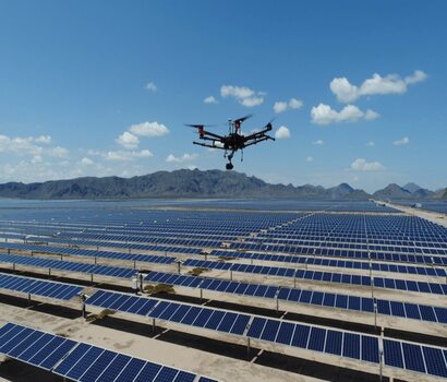
Elaborate survey operations have to be performed on solar power plants, which are most often spread across acres of irradiated land. However, with automation taking over every industry, why solar power plants should remain an exception?
Yes, Drones with RGB and thermal infrared imagery are excelling at offering practical solutions to surveying challenges of the solar power plants.
Ways Drones work for a solar power plant
- Site planning and construction
Drones procure data such as topographic mapping, site shading evaluation, water reservoir, and generator proximity to assess the site’s feasibility. Drone flights can also real-time report on construction progress, quality assessment, and project management.
2. Commissioning
It marks a vital step in construction completion and commercial operation of a plant, ensuring that the system and installed equipment meet the designed standards. Images captured by drones serve as valuable pieces of information for the asset purchaser while examining the quality of the built plant.
- Maintenance
Drones enable in-depth information on the health of the solar panels and equipment at a string, module, or sub-module level in a risk-free manner and without shutdown. Measurement and inspection of roof-top panels
Drones can help you protect your personnel from measuring risky sites like roof-tops. It captures roof images effortlessly during pre-installation planning to inspect the condition of the existing system.
- Surrounding features
Drone imagery has proven to be a reliable maintenance tool for many other electric infrastructures like substations, cables, and poles. It allows workers to identify and fix any system anomaly quickly.
Why does a solar power plant need Drone surveying over manual inspection?
1. Turnaround time is much quicker. And higher the efficiency, the greater is the cost savings.
2. Faster inspection in a shorter time that still identifies defects.
3. High-resolution RGB and thermal images reflect top-notch quality results.
4. User-friendly PDF and mobile app formats for processed and analyzed data.
5. Secure portals to store data and ease of reporting and reassessing for future reference.
6. Risk-free surveying.
7. Inspection without plant shutdown.
Looking for a start?
We can help you use Drones to their fullest potential for surveys and do the best to expand your business.
At SES Digital, we are equipped with an array of innovative surveying solutions- High-resolution drone maps and 3D models, Accurate roof measurement 3D solutions, Real-time thermal inspection with thermal camera support, and In-field reporting methods. You can count on SES Digital for the best-in-class Drone services for Roof panel roof installation, design, Inspection, and Commercial solar unit construction.