


Introduction
Aerial survey teams often miss structural problems when using simple hand-held cameras. Dense pipe racks, hot stacks, and live chemical units are hard to see from the ground. Climbing these structures puts workers at high risk, and relying on old blueprints leads to costly mistakes.
Industrial drone inspection services in India turn dangerous site walks into accurate 3D maps. Flight crews use certified drones with thermal cameras, visual lenses, and LIDAR sensors. As a result, plant teams can check flare stacks, pipe bridges, tanks, and roofs safely without shutting down operations or placing technicians in danger.
What Is Drone Inspection and When Is It Used?
Industrial drone inspection uses remote-controlled aircraft equipped with thermal, visual, and laser sensors. Operators fly these drones to inspect plant equipment from a safe distance. Teams use drones when manual climbing is unsafe, scaffolding costs are too high, or a fast survey is needed across a large plant site.
Drone sensors capture clear visual details and surface temperatures. Engineers stream this field data into digital models to track structural wear, find heat spots, spot thin vessel walls, and catch building movement before problems cause unexpected downtime.
- Sensor data from thermal, visual, and LIDAR cameras streams directly into cloud platforms to process point clouds and images.
- Processed spatial data exports straight into CAD software, 3D models, and digital twins.
Which Industrial Assets Can Be Inspected Using Drones?
Stacks and Flare Structures:
Thermal and zoom cameras locate broken insulation, tip wear, and burner flame issues while the flare stays on.
High Roofs and Buildings:
Scanning large industrial roofs reveals hidden leaks and dips, pinpointing trapped water, loose screws, or rusted metal sheets.
Storage and Cryogenic Tanks:
Drones fly around large tanks to inspect floating roof seals, wall dents, rust patches, and damaged outer insulation.
Pipe Bridges and Racks:
Multi-level pipe networks are checked for shifted supports, wet insulation, and small leaks without forcing workers onto narrow beams.
Boilers and Closed Vessels:
Protective cage drones fly inside dark, tight spaces during planned stops to check brick linings and dirty tube bundles.
Hard-to-Reach Sub-Structures:
Deep foundation pits, loading docks, and cooling towers are checked safely without building scaffolding or using crane baskets.
How Do Drones Support Building and Structural Inspections?
Structural damage builds up quietly whenever water leaks past seals or concrete cracks out of view. Thermal imaging catches subtle surface temperature changes across building walls, pointing out hidden water leaks long before wet spots show up inside. Clear aerial photos reveal tiny cracks in concrete columns, rusted bolts, and failing paint on key steel joints.
Raw Aerial Data ──► Thermal & Visual Spatial Mapping ──► Structural Capacity Checks
Combining drone survey files with ground-based 3D laser scanning services gives plant teams an accurate digital picture of their facility. Operations teams use these updated spatial models to double-check weight limits before placing heavy new machinery on older floors.
How Are Drones Used for Manufacturing Industry Inspections?
Busy manufacturing plants present tough layout challenges. Overhead cranes, conveyor lines, and ventilation ducts block clear views from the ground. Flying compact drones inside high-bay spaces and open yards lets technicians inspect critical equipment without stopping daily production work:
| Asset Category | Inspection Target | Sensor Payload | Useful Output |
| Overhead Cranes | Track alignment, weld cracks, hoist cables | High-zoom camera | Wear reports, alignment alerts |
| Warehouse Shells | Solar panels, insulation gaps, roof trusses | Thermal + Color camera | Hotspot locations, leak maps |
| Exhaust Systems | Duct rust, open joints, stack plumes | Gas sensors + Thermal | Leak tracking, insulation audits |
| Material Yards | Stockpiles, aggregate piles, yard drainage | LIDAR + Camera | Volume counts, ground elevation maps |
Using drone building inspection services in India across factory sites removes the need to move scissor lifts through narrow aisles or hook safety lines onto high steel beams.
What Role Do Drones Play in Chemical Plant Inspections?
Flying inside a chemical plant requires strict safety steps. Pilots must watch out for hazardous gas zones, strong magnetic fields near power equipment, and tightly packed pipe arrays. Booking an oil and gas drone inspection in India or using drones services for chemical plant in Vadodara sites gives engineers a clear view of dangerous areas while keeping ground crews out of harm’s way.
Hazardous Operational Zones: Zoom lenses and Optical Gas Imaging (OGI) cameras pinpoint small gas leaks around valve stems and pump seals without sending workers into dangerous spaces.
High Flare and Pipe Racks: Calibrated thermal sensors map temperatures along steam lines to locate hidden moisture and pipe rust under insulation without peeling off protective covers.
What Data Can Industrial Inspection Drones Capture?
Drone sensors capture clear, location-tagged data formats that import straight into plant management software:
Thermal Temperature Maps: Temperature points show broken insulation, heat loss, and overheating electrical switches.
Millimeter-Grade Point Clouds: 3D coordinate webs created from LIDAR or photo data build accurate spatial models.
High-Resolution Maps: Stitched overhead photos build complete, clear map views of entire plant sites.
Gas Detection Images: Special optical sensors make invisible chemical fumes visible on flight screens.
Volume Measurements: Calculated stockpile volumes help ground teams track inventory and site work.
How Drone Inspection Speeds Up Plant Turnarounds and Outages
Planned plant turnarounds are among the most expensive events in process manufacturing. Every extra hour spent offline cuts directly into plant income. In the past, turnaround planning relied on simple walk-throughs and rough guesses. Workers had to build scaffolding just to check high pipes, flare tips, and vessel interiors, a process that took days before repair work even started.
Drone inspection changes this approach by shifting discovery work ahead of the shutdown date. Flying drones weeks before a scheduled outage lets engineers finish detailed equipment checks while the plant is still running.
[Pre-Outage Drone Survey] ──► [Scope & Priority Check] ──► [Targeted Repair Work]
Targeted Scaffolding: Instead of building scaffolding everywhere, plant teams build staging only where drone thermal images or photos show clear damage.
Pre-Ordered Parts: High-zoom drone photos reveal exact bolt patterns and part wear ahead of time. Purchasing teams can order needed pipe spools, gaskets, and metal plates before equipment cools down.
Confined Space Pre-Screening: Cage-protected drones enter steam drums, tanks, and boilers before workers step inside, checking oxygen levels, wall strength, and dirt buildup to ensure safe access.
Connecting Drone Data with Predictive Maintenance Systems
Inspection photos saved in separate folders rarely lead to long-term improvements. The true value of aerial surveys appears when raw flight data links straight to plant predictive maintenance software and asset tools.
When thermal maps from a drone flight import into maintenance software, the system cross-references surface temperatures with live motor vibration, pressure changes, and output numbers.
Drone Thermal Maps + Smart Motor Sensors + 3D Laser Scanning
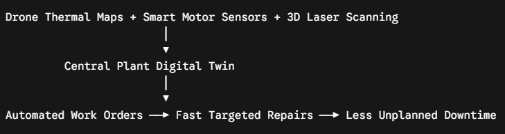
- Early Issue Detection: A drone thermal pass spots a hot area forming on a steam line insulation cover.
- Sensor Verification: The maintenance system checks nearby line pressure and vibration data from field-mounted smart motor sensors to assess actual risk.
- Digital Twin Mapping: The damage location matches directly onto the plant’s 3D scanned model, giving repair crews exact height and spot coordinates.
- Automatic Work Orders: The asset system creates a work order complete with exact heights, safety gear requirements, and replacement part numbers.
This connected setup turns routine flights into valuable updates for ongoing site checks, helping plants switch from emergency fixes to planned asset care.
What Should Companies Check Before Choosing a Drone Inspection Provider?
Choosing a drone vendor requires looking beyond basic hardware to check safety rules, flight licenses, and data skills.
Government Rules and DGCA Compliance
- Confirm that the vendor flies DGCA type-certified drones registered on the Digital Sky Platform with valid Unique Identification Numbers (UIN).
- Ensure pilots hold current Remote Pilot Certificates (RPC) issued by DGCA-approved flight schools.
- Check their experience getting airspace approvals across Red, Yellow, and Green zones, including filing NOTAM notices near restricted areas.
Technical Skills and Engineering Output
- Check that cameras match job needs (thermal accuracy within ±2°C, 20MP color cameras, dual thermal/visual video).
- Ask if the vendor provides raw images or complete CAD models, clash checks, and engineering reports.
- Review safety plans for working in live plants, including hazardous area steps and magnetic shielding near high-voltage gear.
How to Choose Drone Inspection Services in India?
Picking an aerial inspection partner requires a simple plan that connects flight results straight to daily repair work.
Vendor Selection Checklist
- Check DGCA registration, legal drone papers, and pilot certificates.
- Review past work records in active chemical, agrochemical, or refinery plants.
- Check camera calibration papers and photo resolution limits.
- Ensure their team can turn point cloud files into usable CAD and BIM drawings.
- Review sample reports to ensure clear fault scoring and priority ratings.
Engineering teams apply the SES Digital Physical-to-Digital Precision Matrix™ to convert drone data into clear maintenance steps across four phases:
- Spatial Reality Capture: LIDAR scans and drone photos set a firm spatial baseline across the site.
- Predictive Asset Telemetry: Thermal images and process sensor readings map onto the baseline to spot equipment stress.
- Human-Process Kinematics: 3D models check repair access paths, worker movements, and crane space for turnaround jobs.
- Unified Dashboard Sync: Drone files, 3D laser scans, site progress monitoring tools, and predictive motor sensors feed into one central plant model.
Using specialized drone inspection for manufacturing industry sites helps operators avoid unbudgeted repair rework, reduce worker safety risks, and keep physical plants aligned with updated digital models.